Dates ........ Thursday, August 29, 2002
Miles ........ 11.5 miles
From ........ Orbeton Stream tent camp
To ............. Crocker Cirque camp
Weather ... Overcast, cooler - 60's, gusty winds, a light shower overnight.Thursday, August 29, 2002
Lone Mt. 3260', Spaulding Mt. 4000', Sugarloaf Mt. shoulder 4237', South Branch Carrabassett River, Crocker Cirque.
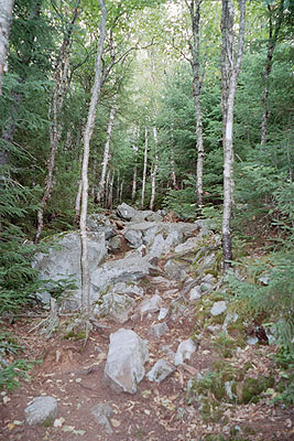
It was a difficult climb up Lone Mountain due to the extremely rocky and rooty nature of the trail, combined with the elevation increase. The trail leveled off somewhat then dropped into Spaulding Mt. lean-to. There I took a lunch break, got water and re-joined Sly after his supply mission in Rangeley. I also met Christopher, a strong and athletic hiker with some extra trail mix to get rid of. I tried it and found his mix of mango, pineapple, peanuts, raisins, M&M's and banana chips to be sweet, delicious and juicy - even though all were dried.
From the lean-to it was a very steep, rocky climb to the 4000' peak of Spaulding Mt, then an equally steep 600' descent to the 3500-foot mountain shoulder. There the trail was extremely rocky but wooded and somewhat level for almost 3 miles as it traveled a ridge that passed along the base of Sugarloaf's summit. Then it dropped precipitously and treacherously into the Carrabassett River valley along a series of jumbled rockslides and rock formations.
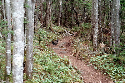
Along the way I flirted with several spruce grouse that insisted the footpath was theirs. I literally had to shoo them out of the way so I could continue. They are very much the opposite of the extremely timid ruffed grouse I am familiar with. I met up with a large group of "peak baggers" on their way to Sugarloaf's summit. I came across a large boulder with a bronze plaque memorializing the efforts of the Main CCC in the mid to late 30's creating the Appalachian Trail in that area. From the shoulder of Sugarloaf Mountain, a popular ski resort, the effects of logging could clearly be seen. In the mountain valleys I could see large treeless patches that looked like farm fields but were actually harvested timber. Dirt logging roads (one of them the dirt road we would cross later today) snaked across the valley.
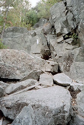
The descent into the Carrabassett River valley was one of the most adventurous I have undertaken since leaving northern NH. It amounted to rock and boulder hopping downhill. It was not a place to loose your footing or fall - such a calamity could easily be fatal. It was nearly 500 feet down to the valley below and I had to work carefully, one stone - one step at a time down the side of Sugarloaf Mountain on the jumble of jagged rocks. As I neared the valley I could hear the water rushing over the rocks below.
Rocky and treacherous trail down from Sugarloaf Mt. Sly and Christopher, one of the hikers we had met earlier, were taking a break on the riverbank when I got there. It was sheltered, out of the raw wind, and the rushing, babbling waters were soothing music to the ears. A lone plank placed between two boulders provided a route across the river's deepest and swiftest channel. I could see from watermarks on the rocks that the water was usually much higher and swifter.
Sly went ahead as I took a break and got water from the beautifully clear river. I learned to take advantage of any water supply when I could. I would drink whatever water I had in my bottle and fill it. Running out of water when hiking us unpleasant and dehydration can have serious consequences.
Once across the river and logging road that paralleled it through the narrow valley, the trail followed a mostly dry streambed up the foothills of Crocker Mountain to a campsite at Crocker Cirque. A privy, small stream, fire ring and several tent platforms made up the campsite, occupied by two groups of people. The campsite was a few hundred feet from Crocker Cirque. Mina and David were there. David was hiking the trail, slackpacking and being shuttled whenever he could, with is wife Mina running support. When she was not driving or hiking to meet him on the trail, she was a regular trail angel, shuttling and helping out other hikers. They were such a sweet couple.
Cirques, also called corries, are created in mountainous areas by erosive effects of snow, frost and ice, and sometimes rock, combined with the downward movement and pressure of a glacier. Acting in all directions on a hollow area between or adjacent to mountains, these combine with downward glacial pressure and forces to sculpt and erode pockets with lowered floors and walls pushed back to form a brim or lip similar to that of a shallow soup bowl. As a glacier retreats or melts, these cirques remain and often fill with water, sometimes as mountain ponds or lakes and sometimes forming the headwaters of a mountain stream where the water breaks through or overflows the brim of the cirque.
The Crocker Cirque is a perfect example of this. Normally containing a pond of water several feet deep, it was nearly dry due to the effects of this summer's drought. This allowed us to see the bowl shaped bottom of the hollow and its pushed up edges. Standing on the edge of this cirque's brim the "lip" was 10-12 feet high and a little wider at its base. It very nearly resembled a crater that would result from a meteor crashing into the earth. This becomes more evident as the cirque is viewed as a whole from a distance and from above as its adjacent mountain is climbed.
Sly and I shared a tent platform, pitching our small tents next to one another. Several other hikers came in and set up tents in flat areas in the woods just below the cirque. After supper we explored the cirque.
|
Sun
|
Mon
|
Tue
|
Wed
|
Thur
|
Fri
|
Sat
|
| 08/21/02 | 08/23/02 | 08/24/02 | ||||
| 09/01/02 | 09/02/02 | 09/03/02 | 09/04/02 | 09/05/02 | 09/06/02 | 09/07/02 |
| 09/08/02 | 09/09/02 | 09/10/02 | 09/11/02 | 09/12/02 | 09/13/02 | 09/14/02 |
Spring/Fall hikes - 15 miles/day - Contact Al. aljohn@jmclum.com.
Last Updated 12/26/02