Dates ........ Wednesday, September 4, 2002
Miles ........ 13 miles
From ........ Bald Mt. Brook lean-to
To ............. Horseshoe Canyon Lean-to
Weather ... Rain, high winds and thunderstorms, upper 50's and 60's,Wednesday, September 4, 2002
Moxie Bald Mt. 2629', Bald Mt. pond, West Branch Piscataquis River
It was a very wet morning with thunderstorms and lightning. I had breakfast in my warm,dry sleeping bag then gritted my teeth and put on my wet clothes from yesterday. In order to have dry clothes for "around camp" later, I hike in my wet clothes. They tend to dry as conditions permit. Once my hiking machine gets going, body heat is sufficient to warm them up and dry them out - if it is not wet out. If its wet, I stay wet. I can tolerate wet and warm. If conditions warrant, I will put my windbreaker/rainjacket on to hold in the heat generated by hiking. But that is usually too warm unless its in the 40's or I'm sedentary and not hiking.
So, off I went, slogging along the wet trail. Actually, I preferred that to hiking in sunny, hot humid conditions. My feet were tolerably dry and that mattered the most. The bypass seemed a logical alternative, given the wind, rain, thunder and lightning. A hiker on a bald mountain summit in a thunderstorm is a walking lightning rod. NO thank you, I don't need that much adventure!
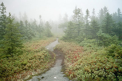
It was pretty, hiking through the fog, mist and rain. The rain and thunderstorms abated when I reached Moxie Bald lean-to on the base of the other side of Moxie Bald Mt., but it was still foggy and misty. The AT circled the end of Bald Mt. Pond then followed Bald Mt. Stream to its junction with the West Branch Piscataquis River. The trail crossed right at that junction, where the river was about 150-200 feet wide, but shallow. After scouting the banks for a while I found what I thought was the best route across, stone hopping and hoping to keep my boots on and dry.
Summit bypass trail (Old AT and BlueBlaze bypassing summit of Moxie Bald in bad weather.) After the successful river crossing the AT followed the north bank of the Piscataquis River's West Branch. As it did, the river channel became a deep gorge. When I reached the Horseshoe Canyon lean-to, the bank was very steep and high above the river. I had to scramble and climb down to get water. It was almost too steep to safely navigate. I had to dig my boots in and pull myself up with trees, rocks and roots found along the bank.
Two tree stumps immediately behind the shelter were swarming with termites. I wonder how the shelter avoided becoming infested. Sunshine joined me at the shelter a short time after I arrived. We chatted, I set up my tent in the shelter as I did before, we ate and turned in for a good night's rest. No one else came by or joined us. Tomorrow I would be in Monson, my next resupply point. I was looking forward to getting cleaned up and eating well - again, and I was looking forward to Maine's legendary 100-mile wilderness. Mt. Katahdin and the completion of the AT followed that. I was getting close - and excited. OK- I was getting hungry, too - but hikers are always hungry!
|
Sun
|
Mon
|
Tue
|
Wed
|
Thur
|
Fri
|
Sat
|
| 08/21/02 | 08/23/02 | 08/24/02 | ||||
| 09/01/02 | 09/02/02 | 09/03/02 | 09/04/02 | 09/05/02 | 09/06/02 | 09/07/02 |
| 09/08/02 | 09/09/02 | 09/10/02 | 09/11/02 | 09/12/02 | 09/13/02 | 09/14/02 |
Spring/Fall hikes - 15 miles/day - Contact Al. aljohn@jmclum.com.
Last Updated 12/26/02