Dates ........ Friday, August 23, 2002
Miles ........ 9.7 miles
From ........ Full Goose Shelter
To ............. Stealth Camp - Grafton Notch State Park ME
Weather ... Wet, gradually clearing and warming up morning, hot and humid afternoon. Upper 70'sFriday, August 23, 2002
Fulling Mill Mt. South Peak 3395', MAHOOSUC NOTCH, Mahoosuc Arm 3765', Spec Pond 3500', Old Speck Mountain 4180',Grafton Notch State Park ME 26
At 6:45 A.M. on a very wet morning Sly and I left the shelter to take on Mahoosuc Notch, reputed to be toughest and most difficult mile on the AT. Most of the shelter's other residents were headed south. We heard time estimates for completing The Notch ranging from 2 to 5.5 hours. Dennis and his family had done it in about 4 hours, and enjoyed it except for the rain. We were glad it wasn't raining, but knew it would still be wet down there where it probably didn't get much sunshine. The guidebook indicated that ice could be found in caves until late June.
Bruce, the shuttle operator in Gorham told us horror stories about all kinds of lost gear, about hikers pushing their pack ahead of them and having it fall between rocks, never to be seen again, about there being enough lost gear in the notch to open an outfitter's store if only it could be retrieved, which, of course, it could not. He reaffirmed that there was always ice underneath all the rocks, a kind of permafrost where the sun never shined. And we heard from some hikers that it was no big deal, just lots of big rocks and not really much different than other trail sections in Maine.
The following photos will do a better job of describing the incredible Mahoosuc Notch and Arm better than I can. Sly and I did not trade cameras often, so I have a lot of pictures of him navigating The Notch.
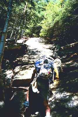
We found out that getting to the head of The Notch was a challenge. The trail descending Fulling Mill Mountain was extremely steep and rocky in many places, as well as wet and slippery. A couple spots required a new technique I call the controlled slide - controlled being the operative word. When I came upon places along the trail where the mountain rock was one big uninterrupted piece of dome-shaped, barren and steep rock, and there were no hand or footholds, or any way to lower myself using trees, branches or roots, and it was too steep for my boots to grab and provide needed traction, I had to resort to the controlled slide. I would just squat and slide down the face of the rock using my hiking boots like skis until, hopefully, I reached the bottom and something to stop me. It worked, but I had a few rough and less than graceful landings.
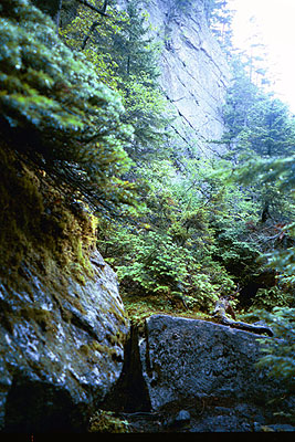
At 8:10 A.M. we arrived at the west end of The Notch. Looking ahead, we could see high sheer rock canyon walls and lots of big boulders jumbled up on the canyon floor. It was not what we had envisioned, though. There was a lot of lush greenery. Trees, bushes, and thick moss seemed to grow everywhere, masking the rocks. Everywhere except where the trail went and wore it off and kept it from growing. It was stunningly beautiful, not stark, hard and cold as we expected. But, we could feel a coolness to the air that we did not experience on the way in. I stuffed my hiking sticks in my pack since they would be useless here. I needed both hands free. Beautiful and intriguing as it was, there was no question we had our work cut out for us.
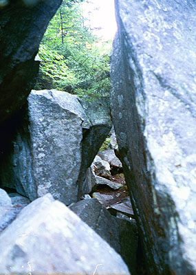
Vertical rock walls define Mahooosuc Notch Over its 1 to 1.25 mile length The Notch dropped a little more than 500 feet in elevation. We were starting at its higher end and traveling downhill - if you could call it that. Indeed, the massive jumble of rocks presented some significant challenges. For one, we could not see very far ahead, even if we were on top of the rocks, because of all the greenery. We were at the mercy of the white blazes to lead us through since we could not see far enough ahead to plot our own route in many cases. Often we found ourselves boxed in with no apparent way out. Then, through a narrow channel or hole in the rocks we would see a blaze - or we could follow the "wear path" underneath, over, around or through the rock maze. A good deal of our time was spent making decisions when there were multiple or conflicting blazes or routes, or when we thought "there must be a better way."
The Appalachian Trail in Mahoosuc Notch
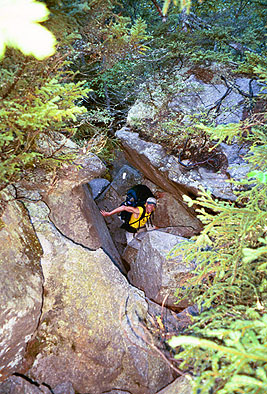
Sly among the rocks and greenery at Mahoosuc Notch At one point there was clearly only one way through. The trail led under and through a little space between two massive boulders. There was no way to get up and over and no way around. In the middle of the space another rock stuck out - we had to decide whether to go over or under this protruding obstacle. We thought there was room enough to wear our packs - removing them would be difficult and time consuming. Sly went first, trying to go under the obstacle. He promptly got stuck, not able to move anywhere. I was less than helpful as I stood by laughing heartily. Finally I regained my composure and was able to reach down and hang onto Sly's pack as he wiggled out from his harness, then lower it to him. I chose the upper route, over the obstacle, and just snaked right through, pack and all. My pack was much smaller and more pliant than Sly's.
There was a certain element of danger in The Notch - as I found out the hard way. Whenever one has to climb around big rocks, one has to be careful not to fall, twist, sprain, or break body parts, or get injured in some other way. And care must be taken to avoid getting permanently stuck or trapped. I was carefully moving back to line up a photo when I stepped on a patch of moss-covered dirt only to have it give way, throwing me three feet to the rocks below. Uninjured, except for my pride, I stood up only to have my leg plunge down between two sharp-edged rocks when another patch of thin soil gave way. Carefully I pulled myself up and out from between the rocks, my leg bleeding from where there used to be flesh. It was not a serious wound, but I had seen the flag: be more careful.
As we got down into The Notch we could hear water running under the rocks. We found several deep caves but only explored one briefly. There was no evidence of ice or permafrost that we could see. Mahoosuc Notch was really just like a giant jungle gym. It was a lot of fun, truly interesting and challenging, and magnificently beautiful. I would gladly do it again.
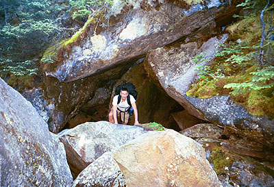
Free Spirit pulls himself up and over a large rock in Mahoosuc Notch. Trail goes left, cave entrance behind me. Since The Notch was such a big unknown, I had only planned on doing the five miles from Full Goose Shelter to Speck Pond. But it only took us 3 hours to get through it and we didn't expend all that much energy. We both decided to go further and reduce the mileage for tomorrow's town stop and re-supply.
The climb out of The Notch - up Mahoosuc Arm - was more treacherous than The Notch because it had the elements of height and steepness added in. It contained huge rocks and many sections of trail that were steep solid domed rock that I couldn't slide up. I had to climb them. Halfway up the arm at a stream crossing we met "Tom in the Woods" and Rain Dog. Rain Dog was from Boiling Springs PA. We took a short lunch break, got some water and talked with them for a while then continued our climb. Mahoosuc Arm proved to be a helluva challenge. We had to pull ourselves up and climb every foot of it.
Climbing a steep section of rock on Mahoosuc Arm Once on top we could look back and see the chasm between two mountains that formed Mahoosuc Notch. It was impressive. After a brief descent we came to the 3500-foot high Speck Pond - the highest pond in Maine. It was a beautiful, pristine pond of sparkling clear, cold water. We thought about a swim and discussed setting up camp and staying, but decided to continue the climb up over Old Speck. After Old Speck it was a steep 2685' descent over 3.5 miles to Grafton Notch State Park (1495' elevation) and Route 26.
As we descended Old Speck we came to a huge open dome-shaped rock ledge overlooking the valley. It offered a spectacular view of the valley below. This is rugged and beautiful country. I can see why people fall in love with Maine. As we continued our descent we came upon two guys setting up a campsite near a stream that crossed the trail. We talked with them as we got water. It was 6:00 P.M. and time for us to be setting up camp. We would have stayed there but they had the only flat spot on the mountainside so we continued on to the valley, even though tired and lame.
We reached the state park and highway and set up a stealth camp on a nice flat spot in the woods just out of sight of the parking lot. We had water, a nice privy and a trash barrel. After dinner we crawled into our tents and slept soundly.
|
Sun
|
Mon
|
Tue
|
Wed
|
Thur
|
Fri
|
Sat
|
| 08/21/02 | 08/23/02 | 08/24/02 | ||||
| 09/01/02 | 09/02/02 | 09/03/02 | 09/04/02 | 09/05/02 | 09/06/02 | 09/07/02 |
| 09/08/02 | 09/09/02 | 09/10/02 | 09/11/02 | 09/12/02 | 09/13/02 | 09/14/02 |
Spring/Fall hikes - 15 miles/day - Contact Al. aljohn@jmclum.com.
Last Updated 12/26/02