Amicalola Falls - Springer Mt. GA to
I 40 Davenport Gap, At the TN - NC border (Part 7)
Dates ........ Wednesday May 8, 2002
Miles ........ 15.5 miles climb 2537', total
From ........ Silers Bald shelter 5460'
To ............. Icewater Spring shelter
Weather ... In the clouds all morning 40's, Afternoon very warm 70's, hazy, humidWednesday May 8, 2002
CLINGMANS DOME 6643', Mt Buckley 6582', Mt Collins 6188', Mt. Love 6646', 5048' US 441 TN-NC state line in Newfound Gap
Frank and I left early, eager to do as much climbing as possible while it was cool. Silers Bald and shelter was in the clouds, we assumed Clingmans Dome would be also. We took a peanut butter snack break at the 5507' Double Spring shelter and then started the ascent of Mt Buckley and Clingmans Dome. The two mountains were connected with a short, high saddle and ridge. The higher we climbed, the colder, windier and foggier it got. We could see patches of cloud blowing by. I had to put on my rainjacket to break the wind. We reached the 6582' summit of Mt. Buckley then, a half-mile further we were on top of 6582' Clingmans Dome where the visibility was less than 100 feet. The awful monstrosity of an observation tower, horribly misplaced on top of this grand mountain in the Smokies was, fortunately, barely visible in the clouds even when standing at its base. I think the structure would be better off in some metropolitan museum of modern art where it can co-exist in style with similar "art" objects. Clingmans Dome and the Smoky Mountains deserve better.
As long as we could not see anything, and couldn't hang around until conditions changed, we strapped on our packs and headed down the mountain. Remember the young couple with the out-of-control aggressive dog? (See 4/29 and 4/30.) It was so nice running into them when they did not have the dog with them. Dogs are not allowed in the Smokies. Their dog should not be allowed anywhere there are other people.
It was a very long, and in places, steep downhill. We crossed the 6446' summit of Mt. Love, descended into Collins Gap at 5886', then crossed the 6188' summit of Mt Collins before descending to the 0.5 mile long side trail leading to Mt. Collins shelter. It was an additional 0.2 mile for water. Instead of hiking the extra 1.4 miles just for water, we figured, correctly, that we could find a spring along the trail. We broke for a snack at the side trail leading to the shelter then moved on. We hiked through miles of Fraser Fir forest with its heavenly balsam scent. At Little Indian Gap, we read the historic marker describing Civil War events that took place nearby. We came to a fenced area with stiles for the trail crossing that was a special area designed to keep wild boar out. WILD BOAR, I surmised after reading the information sign posted there, are responsible for the diggings along the trail and at the Fontana Dam park entrance. Not a naturally occurring native species, they are creating problems and concerns within the park.
The afternoon warmed up considerably, making it uncomfortable hiking in the heat and humidity. We had a long way to go with lots of climbing. At 3:40 PM, we crossed 5048' US 441 at the TN-NC state line in Newfound Gap. It was swarming with tourists and day hikers. Several even asked us to pose for photographs at the state line sign. We posed, got water, and moved on. We had three more rugged miles to go and we were already tired.
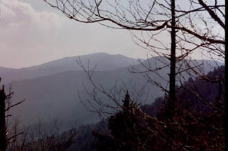
As we hiked the ridge on the way to Icewater Spring shelter we were given a tremendous reward for our efforts; a look back about 10 miles to Clingmans Dome and the nearby mountains we hiked over this morning. The clouds had lifted but the haze made the view less then perfect, but still very satisfying.
We saw a lot of people out "hiking" there. Most would take their packs and water bottles and venture a mile or two into the forest, then return to their cars. Once 5 miles or so away from the road, you rarely saw anyone but long-distance and through hikers. It is one thing to hike the Smokies end-to end (74 miles), and quite another to hike a half day or even a full day in from one end or the middle as so many do. The Smokies are so vast that even hiking their entire length on the AT only gives you a small, but grand, sampling of them. There are hundreds of other trails throughout the Smokies, many intersecting with the AT and thousands of trail miles throughout the park. Something to meet everyone's needs, no doubt.
At 5:45 PM we reached the Icewater Spring shelter. It is one of two at 5920 feet elevation on the AT in the Smokies, and among the AT's highest shelters. Icewater Spring was one of the few that had a privy and it was a nice moldering privy. We were very tired and glad to be there. We weren't keeping as fast a pace as some because we both wanted to take time along the way to stop and enjoy the hike, the scenery and the people. We'd been doing that and wanted to continue doing it because that is what really makes a wilderness journey most worthwhile.
At the shelter were Caribou Frank and I, Pete "Peaks" Lane, Booger and Renegade, Kitchen Sink, Julie and Craig, Scott and Matt. Later, four college kids came along but were denied a space in the shelter (by the other hikers already there) because they had no backcountry permits or reservations. Both are required for overnight stays in the Great Smokey National Park. Through hikers, anyone hiking the entire park from a point 50 miles or more away from its beginning, are exempt from shelter reservations (they have three spaces automatically reserved along the AT for them in each shelter) but still must get the free backcountry permit.
Personally, I would have gladly let the kids stay anyway, since there was enough room for them without crowding. It was not a problem in the end as they had tents and it was not a stormy night. Everyone else ignored them, like they had done something terribly wrong or were inferior. I spent some time with them and found them to be very interesting and good company. They did not know of the permit requirements and drove a couple of hundred miles to hike in the Smokies on a lark, after exams.
|
Sun
|
Mon
|
Tue
|
Wed
|
Thur
|
Fri
|
Sat
|
| 04/24/02 | 04/26/02 | 04/27/02 | ||||
| 05/05/02 | 05/06/02 | 05/07/02 | 05/08/02 | 05/09/02 | 05/10/02 | 05/11/02 |
| 05/12/02 |