Amicalola Falls - Springer Mt. GA to
I 40 Davenport Gap, At the TN - NC border (Part 7)
Dates ........ Wednesday, April 24, 2002
Miles ........ 10.6 miles
From ........ Neels Gap Walasi-Yi
To ............. Low Gap Shelter GA.
Weather ... Mid-60's, partly cloudy, breezy.Wednesday, April 24, 2002
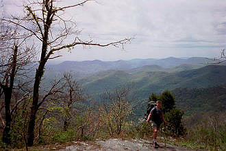
Cowrock Mountain GA 3842'
I loved Neels Gap Walasi-Yi and could have easily stayed there a long time. Winton and his guys were so nice they made leaving real hard.
I got up and tended to some last-minute business. Dan wanted to sleep in. He assured me that he could catch up somewhere between here and the next shelter. Paul was taking it easy on his blisters and Mongoose was headed somewhere up north to meet his dad. My resupplied pack weighed 34 pounds, full of food and water, and felt awfully heavy. I hit the trail alone about 10 A.M.
I broke for lunch at a spring along the trail and Dan caught up with me. I was glad to see him. His pack weighed about 12 pounds less than before - but, I thought, was still a bit on the heavy side. He had new hiking sticks - the bamboo ones someone had discarded at Neels Gap, and he was raring to go.
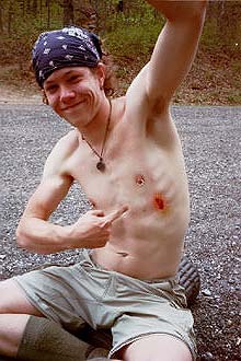
We reached the summit of Cowrock Mountain. A rocky opening provided great views to the southeast. Coming down into Tesnatee Gap and GA 348, a paved road access point to the AT, Dan caught his hiking stick in a hole along the trail at the same time he was executing a switchback. He fell on his stick end, had the wind knocked out of him and bruised his chest. Although in great pain for a while, he was very lucky - it could have easily been a far more serious injury.
Free Spirit and the view from the summit of Cowrock Mountain.
Dan "the goat" shows off his AT battle wound. We took a break in the parking area of Tesnatee Gap, tended his wound, had some water and trail mix and mentally prepared ourselves for the short but very steep climb up to the ridge. Buckets of sweat poured off me as I made the climb. It seemed senseless, I thought. The trail went from highway 348 steeply up a mountainside, along a ridge, then steeply back down to the same highway. 0.9 trail miles, and about Ľ of a highway mile. There were no spectacular views or scenic wonders up there - so why bother? Why not just have a simple Ľ mile road walk? There was a side trail to a shelter on the ridge and Dan decided to stay there so he could be alone for a while and catch up on his journal writing. He said he'd try to catch up to me someplace further up the trail.
On the way to Low Gap shelter I met a father and son from Arizona out for a short section hike. After they passed, I wished I had taken a photo of them. At the blue blaze side trail to Low Gap shelter, a man from Texas and his wife had set up camp. Her badly swollen knees were bothering her and they were trying to figure the best way to get her off the trail.
Tom, a gentleman from Louisiana, occupied the shelter. Just after I arrived it started raining and continued raining for a couple of hours. Thunderstorms lasted most of the night.
Neal, a big soft-spoken guy with a Texan's drawl, came to the shelter and studied the maps and guide I had. It seemed the easiest way out for his wife, short of a helicopter flight or being carried out on a stretcher, was the 4.2-mile hike to GA 348 at Hogpen gap. It was the shortest route but not an easy walk by any means. At the road, they hoped to flag down a passing car, get a ride to Neels Gap and shuttle from there to their car. Neal said he'd like to come back sometime and try to hike the entire trail, maybe in big sections.
At dusk, the mice were running all over the place. I set the mousetrap and got seven mice in the shelter that night. Then I was able to sleep a little better.
|
Sun
|
Mon
|
Tue
|
Wed
|
Thur
|
Fri
|
Sat
|
| 04/24/02 | 04/26/02 | 04/27/02 | ||||
| 05/05/02 | 05/06/02 | 05/07/02 | 05/08/02 | 05/09/02 | 05/10/02 | 05/11/02 |
| 05/12/02 |