
Dates ........ Wednesday, April 25, 2001
Miles ........ 16.2 miles
From ........ Star Haven (AKA: Rice Field ) Shelter
To ............. Bailey Gap Shelter
Weather ...
I left the shelter and continued the trek along Peter's Mountain ridge. It was a moderate ridgewalk for 7 miles at 3400-3700 ft. elevation until Dickenson Gap, then it turned into a climb followed by a brief sharp descent and another brief climb, then a long 1500 foot descent into Stony Creek Valley and past Pine Swamp shelter, where I took a short break.
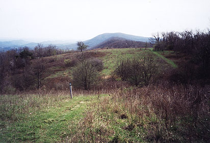 |
| Looking ahead to Peter's Mt. ridge and Dickinson Gap. |
Along the ridge several delta wing jets flew toward me very low and, upon reaching the ridge, turned sharply and climbed steeply. It was awesome, impressive and very noisy. I found myself enjoying another AT air show. Later I learned that pilots doing this may have been involved in Navy radar training for offshore ships hundreds of miles away. Whatever the case, it sure did provide the hiker on the ridge with plenty of excitement! Silver and Coach passed me on the ridge while I was taking a drink and converting my pants to shorts by removing the legs. The other two never did catch up.
At the bottom of the descent from Pine Branch Shelter the trail came within 100 feet of VA 635 and a USFS parking area, marked with a big sign. From that point on to the "official" VA 635 crossing the trail took a nasty, unnecessary and impractical series of steep, badly eroded, short climbs and descents, switchbacks and rough trail to avoid what could have been a short, pleasant roadwalk along a quiet section of road. This was one of the few times I actually felt angry with the folks that laid out the trail. If I had it to do over again, I'd have walked the 100 feet to the USFS parking area and VA 635 clearly visible from the trail, and had a pretty, relaxing and gentle roadwalk to the point a couple of miles further north where the trail crosses VA 635. It would have cut out a lot of unnecessary and unpleasant crap.
Let me also add my dissatisfaction with the AT Conference / USFS maps at this point: they are poorly detailed and with their crude 100 foot contour interval and lack of wide area coverage they are virtually useless for serious orienting. They serve as a crude guide, at best. I much prefer maps similar to the PA series, which are the standard topographical maps, marked up to include the AT and its features. At least with good maps a hiker can know where he is and make intelligent choices. Enough complaining.
After the VA 635 crossing, there was a short section of trail that went through a pine forested valley. Very pretty, cool and refreshing. Then the trail ascended Big Mountain steeply 1300 feet to Bailey Gap and the shelter there. It was a challenging and tedious, though not difficult, climb. Hot, sweaty and tired, I was the only one at the shelter. I went to the spring and got my water supply for the evening and morning. All alone at the shelter, I was in bed by 7:00 PM. Barred owls hooted to each other, one was very close.
|
Sun
|
Mon
|
Tue
|
Wed
|
Thur
|
Fri
|
Sat
|
| 04/18/01 | 04/20/01 | 04/21/01 | ||||
| 04/29/01 | 04/30/01 | 05/01/01 | 05/02/01 | 05/03/01 | 05/04/01 |