Dates ........ Thursday, September 20, 2001
Miles ........ 12.4 miles, climb 3800 feet
From ........ Cherry Gap Shelter
To ............. Yellow Mt. Gap Overmountain Shelter
Weather ... Very wet AM, thundershowers, 50's, remaining cloudy, cool and wet all day.Thursday, September 20, 2001
Little Rock Knob (4918'), Roan High Knob/Cloudland (6285', highest elevation on this hike), Carvers Gap (5512'), Round Bald (5826'), Jane Bald (5807'), Low Gap (5050'), Elk Hollow Ridge (5180'), Yellow Mountain Gap (4682')
Last night's thundershowers continued until 9 AM this morning, then they let up and became just light showers. I started out on the trail at 10:20AM. Linguini had left shortly after daybreak, sporting his black plastic finery. I had no doubt of his determination and that he would meet his objectives, barring a severe blizzard. I questioned if he would be comfortable doing it. Expecting to be swarmed by bees on the way out of the shelter again, I put on all my heavy winter gear, leaving myself well covered and padded and with very little exposed flesh. It worked. The bees swarmed and tried to sting me but were not successful - this time. As soon as I was safely away from the angry demon's nest, I removed the extra layers of clothing. I had to keep them dry.
On my way up to Little Rock Knob, I saw four deer. They weren't in a hurry and continued to graze as I climbed the steep knob. On top there was supposed to be excellent views. All I saw was the characteristic wall of gray; the inside of a cloud. This dampened my enthusiasm (pun intended) for the long and arduous climbing ahead, to the summit of Roan High Knob. No doubt that would be in the clouds too. At least it was cool today, making the 100 percent humidity and perspiration from exertion tolerable. The strong breeze kept my glasses from fogging
After Little Rock Knob I dropped into Hughes Gap, then climbed steeply up to Ash Gap. In all I had to "give up" (descend and re-climb) 1,100 feet from the high point of Little Rock Knob to Roan's Summit. Downhill is wonderful - unless you have to climb right back up to regain the lost elevation. That's often an Appalachian Trail hiker's predicament.
At my 1:15 lunch break, it was so cool when I stopped that I had to put a jacket on. I resumed hiking wearing a long sleeved shirt over my T-shirt since the breeze was so strong and cool and it seemed to be getting cooler as I gained elevation. My preferred hiking method on a wet day is to let the clothes I'm wearing get wet and either stay wet or dry on me as I hike. Rainwear keeps one warm, clammy and wet inside, and that is OK if it's a real cold rain, but too uncomfortable in warm weather. I was cool and damp all day. I much prefer that to hot, humid and sweating buckets on the trail.
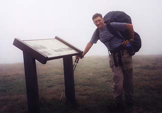
As I gained elevation I was treated to the pleasant aroma that is usually found only in the higher elevations of the AT: The heavenly aroma of balsam pine. I achieved the first summit of Roan at 2:30. Visibility was maybe 100 feet. I needed water and the guidebook said there were restrooms and running water, along with fabulous rhododendron gardens and the old Cloudlands resort site on top. The map was no help, with its course scale it didn't even clearly pinpoint the summit. For reference, I took a compass bearing and set off in search of the restroom. I heard but could not see a car, but headed toward the sound. There I found the restroom. I filled my water bottle and headed back to the trail - or tried to. I had to use my compass and walk around a while before I found the trail in this heavy cloud cover. Had I not taken the reference reading, I'd been in deep doo doo. Along the way I found the plaque commemorating the Cloudlands resort and its unique opulent turn-of-the-century lifestyle, with the Tennessee - North Carolina border running right through its former ballroom. All that remained now was the plaque, a non-operational drinking fountain and a grassy field.
TN/NC border and Cloudlands Plaque, first summit of Roan High Knob
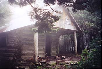
Roan High Bluff - 6285' - Fire Warden cabin converted to AT shelter - highest shelter on the AT and highest point on this hike. Having located the trail, I had only a short distance and very little climb to the second and actual summit of Roan High Bluff and the shelter there. I met another southbound section hiker, Surefoot, on the way to the shelter. The shelter was a neat old fire warden's cabin. It too was, of course, shrouded in cloud mist. It was late - 3:30 PM when I got there. I was tempted to stay. It only took me a half hour to cover the 1.3 miles downhill to Carvers Gap (5512'). There I saw several day hikers, the road entrance to Roan's summit and the trail leading up to and over Round Bald (5826'). After a short break, I wearily pushed on. The rain stopped and I was now just below the cloud's ceiling which was enveloping the top of Roan Mt. As I climbed Round Bald, the ceiling seemed to be lifting and it was acting as if it wanted to clear up. Wanted to, but couldn't.
I took several interesting pictures from and near the top of Round Bald. The bald provided a limited view into the valley below and the surrounding mountains, with Roan towering over them all, its crown in the clouds, where I had been a few hours ago. It was a unique section of trail to the bald's top, a 3-foot wide path of crushed stone. Beyond that it was a rut in the soft earth perhaps 8 inches wide and 6 to eight inches dep. That was tough walking. My goal was the Overmountain Shelter. That would keep me one full day ahead of schedule. The Stan Murray shelter was 2 miles short of that and I could stay there if darkness fell or if I was too tired, but I was pretty sure I could go the longer distance since it was mostly downhill.
After I climbed Round and Jane Balds and passed through Grassy Ridge it got to be real nasty going. I found myself descending steeply through mixed woodlands and an old orchard with a very poorly marked trail in diminished light. It was extremely muddy, steep and slippery underfoot. I slipped and fell several times before the trail took to an old roadway and firmed up. I reached the Stan Murray shelter around 6 PM, my usual limit for hiking time. But I wanted to push on the extra miles to Overmountain shelter at Yellow Mountain Gap. I put on my headlamp just in case.
At 6:50, nearly dark, I reached the spring in front of Overmountain shelter, got water, then made it to the shelter by 7:05 PM - just a tad after dusk. I got a couple pictures of the pretty mountain valley the shelter overlooked, turned on my headlamp and set up camp in the shelter alone, except for the four-legged critters.
Overmountain was an old barn converted to a shelter. It sat overlooking a beautiful hillside and mountain valley. As it got dark I could see a single light off in the valley below. It was peaceful and beautiful. I was tired, hungry and my feet hurt - especially my left foot, which seemed numb near the toes. At 9 PM I tuned in President Bush's speech and listened carefully to every word. Parts of it brought tears to my eyes and it made me very proud to be an American. I thought it one of the best speeches I had ever heard a President make. After the speech I turned off my little radio and went to sleep.
|
Sun
|
Mon
|
Tue
|
Wed
|
Thur
|
Fri
|
Sat
|
| 09/19/01 | 09/21/01 | 09/22/01 | ||||