
Dates ........ Wednesday Sept 27, 2000
Miles ........ 18.2 miles
From ........ Rt. 9 - Autumn Inn, Bennington, VT
To ............. North Adams MA
Weather ... AM in the 40's, clear, PM in the high 50's, mostly clear
My night in Bennington was most enjoyable and refreshing, despite the bad news about problems at home. Fortunately, they are nothing that can't wait until I get back. I had a hard time getting a hitch back to the trail crossing - all the soccer moms and their kids did not want to give me a ride. I went back to the motel to inquire about a cab and the desk clerk closed up and gave me a ride up to the trail. How sweet of her; I appreciated it.
I started up 3300 foot Harmon Hill from Rt 9, at 2300 ft. It was a steep climb up rock steps much of the way. I focused on slow and steady and made the climb in about an hour. At the top there were nice views of Bennington from a clearing. I chatted briefly with another hiker.
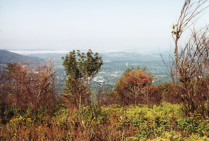 |
| View of Bennington VT from Harmon Hill |
I have formed an opinion about the Long Trail and AT in southern Vermont: It is really a Vietnamese rice paddy training ground in disguise as a hiking trail. It is the wettest, sloppiest trail I have ever had the displeasure to be on. As soon as I hit a dry spot, it would turn sloppy and mucky again. It slowed me down. But, the scenery, marshes and beaver ponds, were very pretty.
Congdon Shelter was a rest point - I got up on the picnic table where there was no mud. But from here, it just got worse. Seems they routed the trail through the biggest swampland in the state. The Indians probably paid us to take this land off their hands.
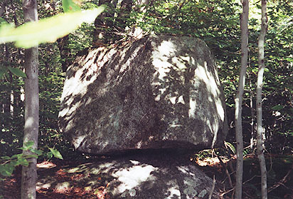 |
| Balanced rocks near VT-MA border |
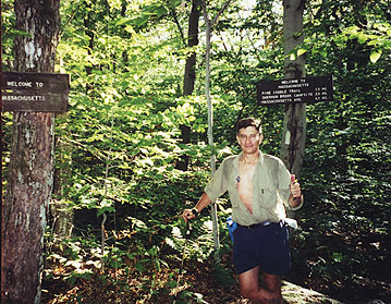 |
| Free Spirit at the VT - MA Border |
Near the border with Mass there were two big balanced boulders. I wonder if they were naturally occurring, or the handiwork of ambitious men. Maybe the early settlers put them there for a place to keep their feet dry. In any case, they were interesting enough to photograph. At the Vermont - Massachusetts border, clearly marked with several signs, I met up with a northbound section hiker just starting out. I posed for a photo and moved on to Eph's Lookout where I surprised a couple in the midst of lovemaking. Not wanting to disturb their romantic interlude, I quickly snapped my scenic photo and moved on without causing them to miss a beat.
In Massachusetts they call trails through big chunks of rock "cobbles". The cobbles just beyond the lookout were interesting and challenging. "Lets be careful here, I don't want to get hurt this close to the end of the trail", I said to myself. The steep, sharp rocks reminded me, for a moment, of New Hampshire - only in NH they would have gone steeply up a mountain for several miles instead of a few hundred feet.
The trail ran along the very pretty Sherman Brook and gorge, at one time the water supply for North Adams, into a back yard and on to MA route 2, then across an elaborate foot bridge over railroad tracks and the Hoosic river, past what was once the industrial area in North Adams. Beyond that it ran up to the base of Mt. Graylock but I turned off, heading toward the only motel in town besides the Holiday Inn.
I might have been better off at Holiday Inn. The motel charged an outrageous $69.00 a night for a room with a double bed, no telephone, not even a clock radio or alarm clock, and a rusty stall shower. It was clean and it was about the only game in town. I got a couple of sandwiches and breakfast food from the supermarket across the street, called home from a payphone, ate, and turned in early.
|
Sun
|
Mon
|
Tue
|
Wed
|
Thur
|
Fri
|
Sat
|
| 9/20/00 | 9/22/00 | 9/23/00 | ||||